Greek and Roman Maps
Oswald Ashton Wentworth Dilke
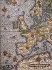
In "Greek and Roman Maps", O. A. W. Dilke follows the development of map-making skills, beginning in Babylonia and Egypt, through the contributions of Greek scientists and Roman administrators and surveyors, to the Age of Discovery. He provides examples of the full range of Greek and Roman maps, including town and building plans, itineraries and road maps, sea itineraries, and maps in art form.
"It is an extremely useful book, packed with information, simply and succinctly expressed... there is no doubt that it was Greek theoretical thinking and a growing knowledge of geography, combined with the practical demands imposed upon the administrators of the Roman Empire, which led to the development and widespread use of maps more or less as we know them." - Mary E. Hoskins Walbank, "Echos du monde classique".
"It is an extremely useful book, packed with information, simply and succinctly expressed... there is no doubt that it was Greek theoretical thinking and a growing knowledge of geography, combined with the practical demands imposed upon the administrators of the Roman Empire, which led to the development and widespread use of maps more or less as we know them." - Mary E. Hoskins Walbank, "Echos du monde classique".
Категории:
Година:
1985
Издателство:
Cornell University Press
Език:
english
Страници:
224
ISBN 10:
0801418011
ISBN 13:
9780801418013
Серия:
Aspects of Greek and Roman Life
Файл:
PDF, 18.43 MB
IPFS:
,
english, 1985
 Amazon
  Barnes & Noble
  Bookshop.org
Искате ли да добавите книжарница? Свържете се с нас на support@z-lib.fm
 Конвертиране на файлове
 Още резултати от търсенето
 Други предимства


Най-често използвани термини
Свързани списъци с книги